


Group strives to control erosion of area waterways
Minnesota is home to a variety of geographical features, but chief among them are its bevy of waterways, lakes, and rivers.
These cut across a landscape peppered with agricultural plots of differing size and shape. Proper maintenance, monitoring, and understanding of their features is key to both upholding and sustaining their natural shape and flow. This is where Steele County Soil and Water come in.
SCSW, which is a local unit of government, sees proper natural resource management as their manifesto. SCSW Conservation District has been serving the county since 1946.
As an organization, they strive to coordinate measures which help to prevent and control both erosion and flooding as well as put forth efforts aimed at enhancing the local wildlife. They also help to further develop the local economic base and provide for recreational regions within the landscape. In essence, they manage the soil under our feet and the water which flows across the county.
Eric Gulbransen, district manager for SCSW, explains that roughly 99 percent of creeks in the area are increasing their bank erosion in the events that they’ve encountered as of late. He said this sort of erosion “takes a heavy toll on all our waterways.”
One solution is to keep the water on the surface through wetland restoration and storage. This entails part of a larger project aimed at renovating and utilizing Steele County’s wetlands.
Gulbransen says that, although marshlands are able to hold a lot of water, once these hit their capacity, the water will begin to overflow and cause problems with adjacent waterways, including the all too familiar plight of bank erosion.
These problems are often compounded in the spring, during periods of protracted rainfall. Adam Arndt, district technician forSCSW, says that because of large volumes of rainfall, the ground is sometimes unable to soak it all in fast enough, which causes flooding, runoff, and overflow. If the ground has ample enough time, the soil can soak it up like a sponge.
Without such time, runoff becomes a problem. Arndt said, “Runoff is worse than just rain, you can store the rain in the ground or in wetlands, but as soon as it starts to run, you can’t store it anymore, and that’s when you know you have a problem.” Arndt believes that everyone can do their part to monitor and keep their nearby waterways stable.
One tip he has for homeowners both rural and urban who live near a river or stream, is to avoid throwing leaves and brush over the edge into the water. Trees near a waterway can also be a detriment, as shade produces bare ground which opens the land up to erosion.
Planting and maintaining grass cover near banks is very good, and very simple solution. But Gulbransen advises homeowners to pick a deep rooted grass for areas near water, explaining that this is able to withstand more pressure from erosion, rainfall, and overflow. He jokes that homeowners should “avoid common grasses like Kentucky Blue” as its roots only run three inches.
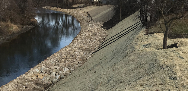
When faced with large scaled jobs, such as the one they worked on in Medford along the Straight River this past fall, SCSW has its own technique. This involves placing and securing “rip-rap,” basically large rocks used at the edge of the bank as well as placing some fill between.
On the large project in Medford, Gulbransen and his team used 4,250 yards of “rip-rap” and 716 yards of fill. A normal sized dump truck is only capable of carrying 10 yards of fill at a time, which give one an impression of the scale entailed in jobs like this one.
Gulbransen and his team spent a long time engineering the specifics of jobs like that one, which often require additional assistance from engineers with a higher class grade. SCSW is only able to independently engineer and work on a project if it is determined to be below grade 5. Those such as the one in Medford, which are squarely positioned at grade 5, require engineers such as Pete Fryer.
Fryer is employed by Southeastern Technical Service Area 7 JPB. Gulbransen explains that JPB, the Joint Powers Board, operates between all 11 Southeastern Minnesota counties, including Steele. He says that “Pete goes to all the counties doing these large projects.” On these large-scale jobs, Fryer is accompanied by an additional engineer and two civil engineering technicians.
Having worked at SCSW for 23 years, Gulbransen reports that he’s only had five of these large scale bank erosion projects, with four of those occurring in this year alone, including the project along the Straight River in Medford. They receive funding from both the state and county, as well as from special grants.
Jobs like this require contractors, something SCSW doesn’t involve themselves in. Gulbransen explained that “we leave all of the contracting up to the land owners.” He added that “it’s sort of a conflict of interest, and so we stay out of it.”
SCSW doesn’t just work on waterways and rivers, it also helps to build windbreaks and provide resources for wildlife plantings. They sell a wide variety of native stock trees and flora, including flowers. These are often used in windbreaks, a familiar feature of Minnesota’s rural areas.
When helping to build windbreaks, SCSW will make planting visits and provide tips for land owners, however they do not participate in the actual planting. Much like the contracting work, this is organized and completed by the landowners.
Windbreaks are an important factor in rural areas where drastic winds can permeate one’s farm or homestead. Arndt explains that these windbreaks are vital to lowering heating and cooling costs, and help to not just keep wind out, but also aid in preventing snow and water from reaching developed areas. Much like most other features of agricultural land, windbreaks will eventually require maintenance and renovation.
In a state of such agricultural prevalence where waterways and rivers, together with marshlands and lakes, spill between farms and cities alike, the work that organizations such as SCSW do can go a long way in preserving and protecting the natural and optimum shape of our land and the water that cuts between it.
*/